Yosemite National Park Maps & Trailhead Navigation Guide
Yosemite National Park maps come in more varieties than almost any park in California, and the first lesson is that no single one tells the whole story. Yosemite covers about 1,200 square miles and has no single street address. The National Park Service says plainly that GPS units do not always give accurate directions to or within the park, and that if your device and a road sign disagree, the sign is right.
Disclosure: Please note that some of the links below are affiliate links and at no additional cost to you, I may earn a commission. Know that I only recommend hiking gear I personally stand behind; when you use my affiliate links, it helps me run this blog and keep all of this content free of charge for readers (like you).
So treat this guide as a way to read the park in layers: where it sits on the map, which road gets you in, which map belongs in your pocket, and where each trailhead is once you are on the ground.
Where is Yosemite National Park on a map?
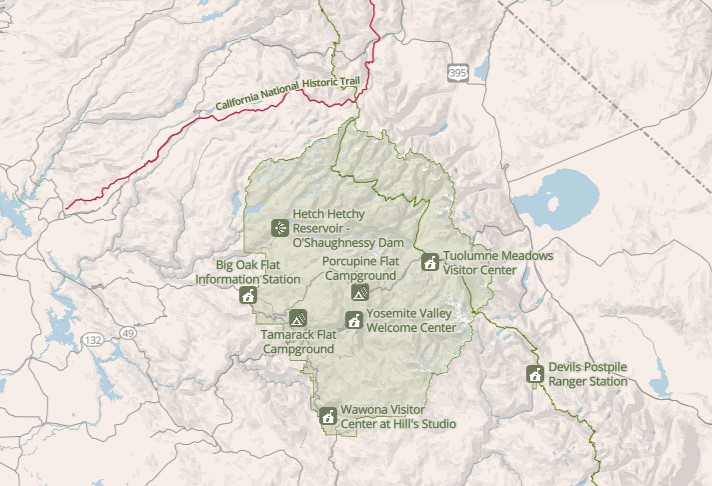
Find Yosemite National Park on a map of California, and you will see it in the central Sierra Nevada, east of the Central Valley. It spans parts of Mariposa, Tuolumne, and Madera counties, with Sierra National Forest on its southeast edge and Stanislaus National Forest on its northwest. Our hubs for Mariposa County hiking trails and Tuolumne County hiking trails cover the two counties most visitors drive through.
NPS lists these distances and drive times, which assume good conditions:
| From | Distance and time | Route in |
|---|---|---|
| San Francisco Bay Area | 195 mi, 4–5 hrs | I-580 to I-205, then Highway 120 (Manteca) or 140 (Merced) |
| Sacramento | 176 mi, 4 hrs | Highway 99, then 120 or 140 |
| Los Angeles area | 313 mi, 6 hrs | I-5 to Highway 99, then Highway 41 (Fresno) |
| San Diego area | 441 mi, 8 hrs | I-5 to Highway 99, then Highway 41 |
| Reno | 218 mi, 5 hrs (about June to October) or 315 mi, 5.5 hrs (all year) | US 395 to Lee Vining, then Highway 120; or via Sacramento |
| Las Vegas | 400 mi, 8 hrs (June to October) or 495 mi, 8–10 hrs (November to May) | US 95 to Highway 120; or via Bakersfield and Fresno |
| Death Valley | 270 mi, 5 hrs (June to October) or 450 mi, 9 hrs (November to May) | Highway 190 and US 395 to Lee Vining; or via Mojave, Bakersfield, Fresno |
Map to Yosemite National Park: which road and entrance?
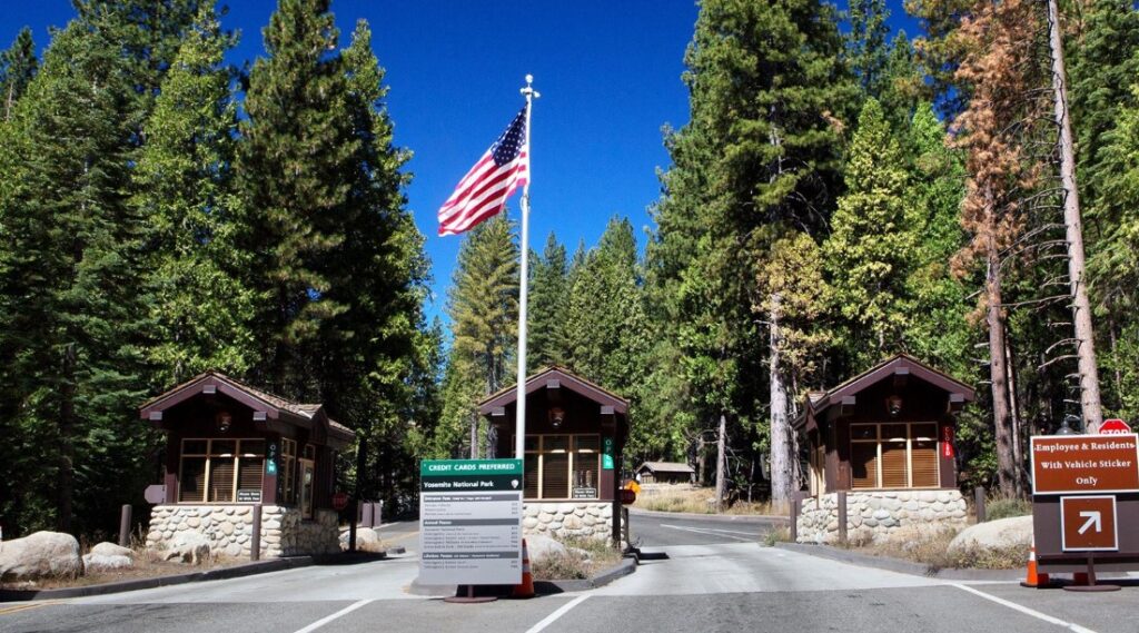
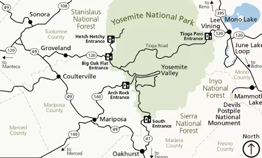
NPS names five ways in: Highway 120 from the west (Big Oak Flat), Highway 140 (Arch Rock), Highway 41 (South Entrance), Hetch Hetchy gateway, and Tioga Pass from the east. Four of them stay open all year, though tire chains may be required from about October through April. Tioga Pass is the exception, because Tioga Road closes with the snow.
| Entrance | Highway | Typical approach | To Yosemite Valley (NPS) |
|---|---|---|---|
| Arch Rock | CA-140, then El Portal Road | From Merced | 11 mi, 20–25 min |
| Big Oak Flat | CA-120 from the west, then Big Oak Flat Road | From Manteca and Groveland | 25 mi, about 45 min |
| South Entrance | CA-41, then Wawona Road | From Fresno and Oakhurst | 35 mi, about 1 hr |
| Tioga Pass | CA-120 from the east, then Tioga Road | From Lee Vining on US 395 | 62 mi, about 1 hr 45 min |
| Hetch Hetchy | Evergreen Road, then Hetch Hetchy Road | Off CA-120 west of the park | NPS lists the Hetch Hetchy parking at 38 mi, 1 hr 15 min from the Valley |
Inside the park, the same drive-time table gives you the distances that matter when you are planning from Yosemite Valley:
| From Yosemite Valley to | Distance | Time |
|---|---|---|
| Bridalveil Fall parking | 6 mi | 10 min |
| Tunnel View | 8 mi | 15 min |
| Crane Flat | 16 mi | 30 min |
| Wawona | 27 mi | 45 min |
| Glacier Point | 30 mi | 1 hr |
| Mariposa Grove | 37 mi | 1 hr 15 min |
| Tuolumne Meadows | 55 mi | 1 hr 30 min |
| Tioga Pass | 62 mi | 1 hr 45 min |
Seasons change the map. NPS says Tioga Road usually closes from some time in November through late May or early June, from Tuolumne Grove (just east of Crane Flat) to the Tioga Pass Entrance Station. Glacier Point Road closes in the same window. While they are closed, you cannot drive to Tuolumne Meadows or Glacier Point, and you cannot enter from the east. Mariposa Grove Road and its shuttle close around November 30 and reopen no earlier than April 15. For current status, NPS gives a recorded line at 209/372-0200 (press 1, then 1).
Fuel is limited. NPS lists 24-hour credit card gas at Wawona, Crane Flat, and El Portal. There is no gas in Yosemite Valley, and none in Tuolumne Meadows anymore, so the nearest options there are Crane Flat or Lee Vining.
Which Yosemite National Park maps should you carry?
Start with the official ones. The NPS maps page links a simple park map that highlights campgrounds, the official park maps from the NPS cartography collection, and topographic maps for the whole park. NPS adds that some park brochures include hiking maps for certain areas.
| Map | Best for | Where to find it | Keep in mind |
|---|---|---|---|
| NPS park map | Roads, entrances, campgrounds, visitor services | NPS maps page | An overview, not a backcountry map |
| Yosemite Valley detail map | Parking, shuttle stops, trailheads in the Valley | Park partners’ sites, Valley information desks | Covers the Valley only |
| NPS area hiking maps | Glacier Point Road, Tuolumne Meadows, Hetch Hetchy | NPS day-hike pages | Access depends on the season |
| NPS topographic maps | Terrain and route planning | NPS maps and trails pages | Less useful for driving |
| NPS app offline map | Navigating with limited signal | Download before you arrive | Needs a charged phone |
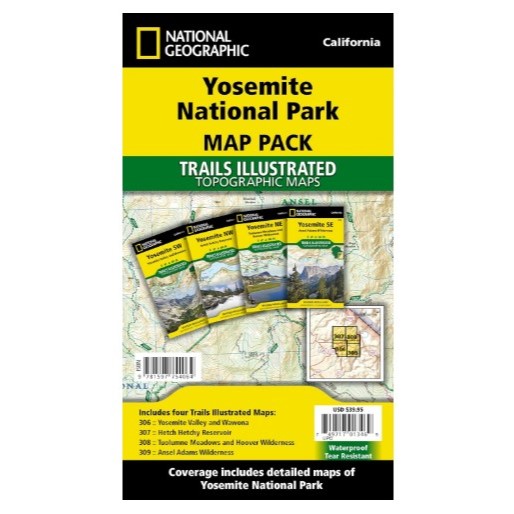
| National Geographic Trails Illustrated Map 206 | Trail and backcountry planning | Yosemite Conservancy shop, outdoor retailers | Scales of 1:80,000 and 1:40,000 |
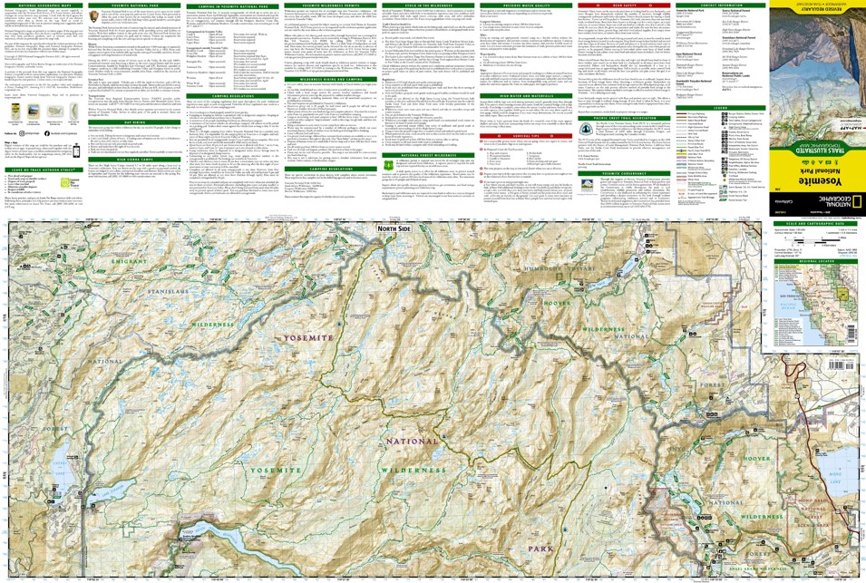
The National Geographic map is the one most hikers buy. It is waterproof and tear-resistant, shows almost 800 miles of mapped trails with mileages between intersections, and adds inset detail for Tuolumne Meadows and Yosemite Valley. For custom topographic maps, the Yosemite Conservancy points readers to CalTopo. If you are weighing a free map against a paid one, our comparison of free vs paid trail maps lays out the trade-offs, and our guide on how to read a California hiking trail map covers scale and contour lines.
Do your phone and GPS work in Yosemite?
Only partly. NPS recommends against relying on GPS units for directions in and around Yosemite. On cell service, NPS lists coverage from AT&T, T-Mobile, and Verizon primarily in eastern Yosemite Valley, with Verizon also in Foresta, Crane Flat, and Wawona. Tuolumne Meadows has no AT&T service and unreliable Verizon service, and the nearest reliable cell and traditional phone service is in Lee Vining, outside the park.
The official NPS Yosemite app lets you download its map before you arrive and use it without a connection. The app’s own listing warns that cell service and Wi-Fi are extremely limited in the park. For app options beyond NPS, see our comparison of the best hiking apps for California trails.
Yosemite Valley trailhead navigation: reading the shuttle map
The free Yosemite Valley shuttle runs year-round, from 7 a.m. to 10 p.m., with no ticket required. NPS says the Valleywide Shuttle runs about every 22 to 32 minutes and the East Valley Shuttle about every 18 to 22 minutes. Pets are not allowed on the shuttles. Four stop numbers do most of the work for hikers:
| Stop | Place | Trail it serves |
|---|---|---|
| #6 | Lower Yosemite Fall | Lower Yosemite Fall Trail, a 1 mi loop |
| #7 | Camp 4 and Yosemite Falls parking | Yosemite Falls Trail to Columbia Rock and the top |
| #16 | Happy Isles | Mist Trail and John Muir Trail trailhead |
| #17 | Mirror Lake Trailhead | Mirror Lake Loop |
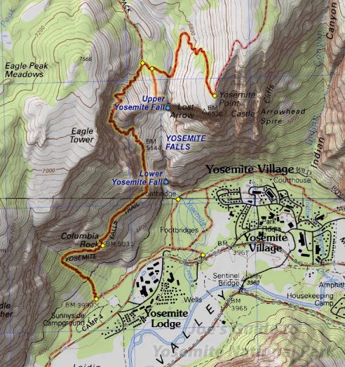
Stop #7 is where our Upper Yosemite Falls hiking guide begins, and stop #16 is where the Mist Trail toward Vernal and Nevada Falls starts. Stop #6 is a different trailhead from stop #7, which is an easy mix-up to make.
Hikes in Yosemite map: where to pin the trails
Instead of memorizing trails, pin them by road. NPS groups Yosemite’s day hikes by area, and the table below uses NPS distances and elevation gain.
| Area | Hike | Distance | Elevation gain | Starting point |
|---|---|---|---|---|
| Valley | Bridalveil Fall Trail | 0.5 mi round trip | 80 ft | Bridalveil Fall parking |
| Valley | Lower Yosemite Fall Trail | 1 mi loop | 50 ft | Shuttle stop #6 |
| Valley | Mirror Lake Loop | 2 mi to the lake and back; 5 mi loop | 100 ft; 200 ft | Shuttle stop #17 |
| Valley | Vernal and Nevada Fall Trails | 1.6–8 mi round trip | 400–2,000 ft | Shuttle stop #16 |
| Valley | Yosemite Falls Trail | 2 mi (Columbia Rock); 7.2 mi round trip | 1,000 ft; 2,700 ft | Shuttle stop #7 |
| Valley | Four Mile Trail | 4.8 mi one way | 3,200 ft | Valley floor, up to Glacier Point |
| Valley | Half Dome Trail | 14–16.4 mi round trip | 4,800 ft | Permit required when the cables are up |
| Glacier Point Road | Glacier Point overlook | 300 yds one way | Paved, gentle | Glacier Point parking |
| Glacier Point Road | Sentinel Dome | 2 mi round trip | 400 ft | Sentinel Dome/Taft Point Trailhead |
| Glacier Point Road | Taft Point | 2.2 mi round trip | 200 ft | Sentinel Dome/Taft Point Trailhead |
| Tioga Road | Pothole Dome | 1 mi round trip | 200 ft | Pothole Dome parking |
| Tioga Road | Dog Lake and Lembert Dome | 3.8 mi round trip | 850 ft | Dog Lake parking |
| Tioga Road | Cathedral Lakes | 7.6 mi round trip | 1,000 ft | Tuolumne Meadows Visitor Center |
| Hetch Hetchy | Wapama Falls | 5 mi round trip | 507 ft | Hetch Hetchy |
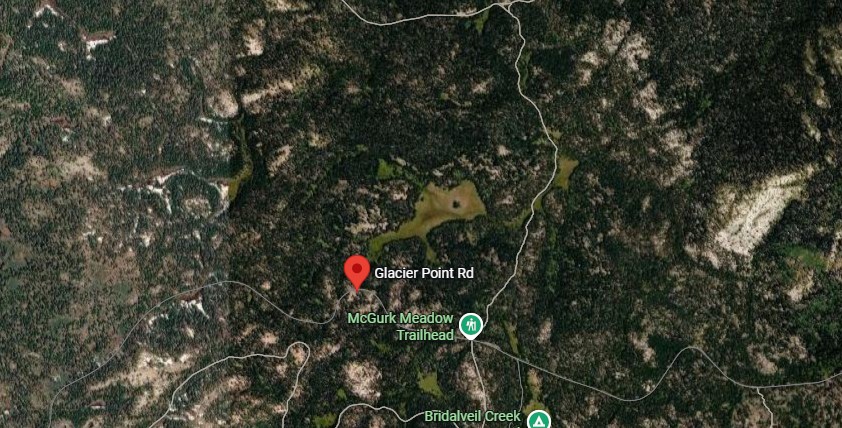
Three notes keep the table honest. First, the Glacier Point Road and Tioga Road rows only work when those roads are open. Second, Hetch Hetchy sits at 3,900 feet and, according to NPS, has one of the longest hiking seasons in the park. Third, Half Dome needs a permit when the cables are up, and our Half Dome permit and cables planning guide walks through it.
For the high country, our guide to Tuolumne Meadows hiking trails goes deeper. For a longer list of what to hike park-wide, see our guide to the best hiking trails in Yosemite National Park.
What can a Yosemite map not show?
A map cannot tell you what the park changed this week. The NPS current conditions page covers roads, trails, campgrounds, fire, rivers, and waterfalls, and NPS notes that its road table reflects only planned or long-term closures. As of NPS’s October 9, 2026 update, Glacier Point Road was temporarily closed for smoke and firefighting, trails in the area around Wawona and Glacier Point were closed, the Mist Trail had a detour open on certain days, and the Valley Loop Trail over El Capitan Bridge was closed on weekdays for bridge work. Check the page before you drive, and see our guide on how to check California trail closures.
Seasons are the other blind spot. NPS says Yosemite Falls can be dry while Vernal, Nevada, and Bridalveil Falls run low late in the year, so a map that promises waterfalls is only half the picture. Our guide to Yosemite weather by month breaks down what to expect when. NPS also asks you to store food properly and stay at least 50 yards from bears in forests and meadows.
The bottom line
Yosemite National Park maps work best in layers. Use the NPS park map to pick a road and an entrance, a Valley or area map to find the trailhead, and a topographic map once the trail leaves the pavement. Download the NPS app before you lose signal, check conditions the week you go, and trust the road sign over your GPS. The park is large enough to hide a wrong turn, and a folded piece of paper is the cheapest way to avoid one.
Yosemite maps FAQs
Is there a free map Yosemite National Park publishes?
Yes. NPS offers a simple park map that highlights campgrounds as a free PDF, and the official park maps are available through its cartography collection. The NPS Yosemite app also includes a downloadable map.
How many entrances does Yosemite have?
Five: Arch Rock, Big Oak Flat, South Entrance, Tioga Pass, and Hetch Hetchy. All except Tioga Pass stay open year-round.
Do you need a reservation to enter?
No. NPS says no reservation is needed to enter in 2026, but the entrance fee applies, and the park does not accept cash. A private vehicle pass is $35 for seven days, and a person on foot or bicycle (16 and older) pays $20. Non-US residents 16 and older pay an additional $100 per person unless they hold an annual or America the Beautiful pass.
Where do you pick up a printed map?
The Yosemite Valley Welcome Center in Yosemite Village has a ranger-staffed information desk. The Tuolumne Meadows Visitor Center, Wawona Visitor Center at Hill’s Studio, and Big Oak Flat Information Station are seasonal, so confirm their dates before you rely on them.
Can you drive to Glacier Point or Tuolumne in winter?
No. Glacier Point Road and Tioga Road close for the season. From about mid-December through March, the first five miles of Glacier Point Road stay open to the Badger Pass ski area.
Where should you stay?
Our guide to where to stay near Yosemite covers lodging for hikers.